Browse wBW ad-free: bercome a member for just $10/year!

Lions Rd one of our best biker roads

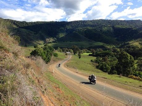
Spectacular views on the Queensland approach to the Lions Rd - sturgis
Spectacular views on the Queensland approach to the Lions Rd

Long before State of Origin footy clashes between NSW and Queensland erupted, there was a clash of governments at the border that has yielded one of the greatest biker roads in Australia – the Lions Rd.
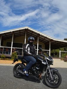
Biker roads:  The Druerys celebrate Mother's Day
Ripples on the Creek is a biker favourite

In 1969 the NSW government rejected calls for a shortcut to link the communities of Kyogle in northern NSW and Rathdowney in southern Queensland. That’s when the Kyogle and Beaudesert Lions clubs stepped in and decided to use the expertise of members and their community to build their own road up and over the craggy McPherson Range via Richmond Gap. They’re still maintaining the road with help from governments and private business and there is a donation box at the border which grateful motorists should patronise.

In the past decade the final gravel sections have given way to a full tarmac surface although it is patchy and often in need of repair. But it’s such a challenge, with spectacular views and myriad twists and turns that it is now one of our favourite biker roads. There is even a good cafe, Ripples on  the Creek, where you can stop, have a coffee and a hearty meal while watching the bikes go by.

It’s a road in two parts: the northern side is an extension of Running Creek Rd with rollercoaster skylines and popular camping spots while the lusher southern side lined with magnificent hoop pines turns off Summerland Way on Gradys Creek Rd and plaits a course where road, rail and creek cross each other every few hundred metres over some one-lane wooden bridges and modern yet narrow concrete structures.
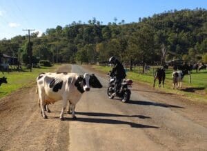
Biker roads: Watch out for cattle on the Lions Rd
Watch out for cattle on the Lions Rd

Dual-sport riders can turn off at Simes Rd and head up the gravel into the Border Ranges Park or take the little dirt detour at Cougal where the trail crosses the creek several times and bathers delight in the cool running waters beneath Roman-style aquaducts. Moss and gravel create slippery surfaces while frequent potholes and corrugations on the inside of corners test the best of suspensions.

Some of the farms are unfenced so cattle can occasionally be encountered around blind corners in the valleys. Wallabies are more common higher up in the forest areas. There are very few opportunities to pass those who want to dawdle and take in the sights, so you have to seize your opportunities when they arise.
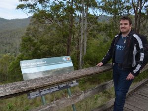
Biker roads: Scenic lookout on the Lions Rd
Scenic lookout on the Lions Rd

If you want to do some sightseeing along the way, you can see the heritage-listed Spiral Loop railway line from the aptly named Spiral Loop Railway lookout. The serpentine rail line includes two tunnels – a 1.6km tunnel at the summit and a shorter tunnel that passes under itself.

Lions Rd and national park maps, brochures and train times are available from the Kyogle Visitor Centre at the northern exit of town or tourist centres in Rathdowney or Beaudesert.

  1. Mark, you should get your facts right about the Border loop on the Lions road before re-printing some P.R. blurb! If you look at the map at the lookout you will see there is two very short curved tunnels on the loop itself. The Border tunnel is 1.1 km long and is over a km or more past the loop, and cannot be seen from the road or lookout. Anyone that’s interested can purchase a very good book on the history of the Lions road, from the museum at Rathdowney.

  2. Tunnel 1 is 232.5 metres long and is at the base of the lookout and can just be glimpsed as a north bound train is entering it. Then the train moves around to Tunnel 2, 176 metres long before curving right then left passing over Tunnel 1 and travelling nearly a km to enter the Border tunnel (1.160 meters) which as I said cannot be seen from the main rd. What you can see from the road when travelling south after the turn-off to the look-out is the portal for tunnel 2. Check Google maps and bring up COUGAL and you will see everything. The book on the Lions road gives all these details.

  3. What you can see from the lookout is Tunnel 1 (232.5 meters) at the base of the lookout, then Tunnel 2 (176 meters) at the back of the hill, the line then curves around and passes over Tunnel 1 then goes for nearly 1 km before entering the Border Tunnel (1160 meters) as I said you of course cannot see it from the road or lookout. What you can see is the portal for Tunnel 2 when travelling south on the road after the turn-off to the lookout. The excellent book about the Lions Road has all the details. So your description of the Border Loop was incorrect!

  4. Go to Google maps-COUGAL-zoom into the loop and the lookout, you can follow the railway line and you will then understand what I am talking about! I have walked into the south portal of the Border Tunnel so I know the area very well!

  5. I am not a train spotter, I am a former Victorian train driver and a 50 year motorcyclist!

  6. The Summerland way and Mt Lindsey highway that you turn off to take the Lions road are actually considered by locals to be as good or better motorcycle ride. If you carry on the Summerland way is nice sweeping curves that later tightens into a superbly surveyed hotmix forest road, then after the border the Mt Lindsey range is yet more corners and some grand views then opening up into more sweepers on the way north to Mt Barney. I used to like both which is a great day ride but if only riding the Lions then you are missing out on a lot.

Comments are closed.